Visit Reunion Island: when to go, what to see and how
Reunion is an island-mountain in the Indian Ocean: the Piton de la Fournaise, one of the world's most active volcanoes, three cirques ringed by ramparts, hiking trails everywhere and a lagoon on the west coast. People go mostly during the southern winter, from April to November, outside the cyclone season.
Discover
Why visit Reunion Island?
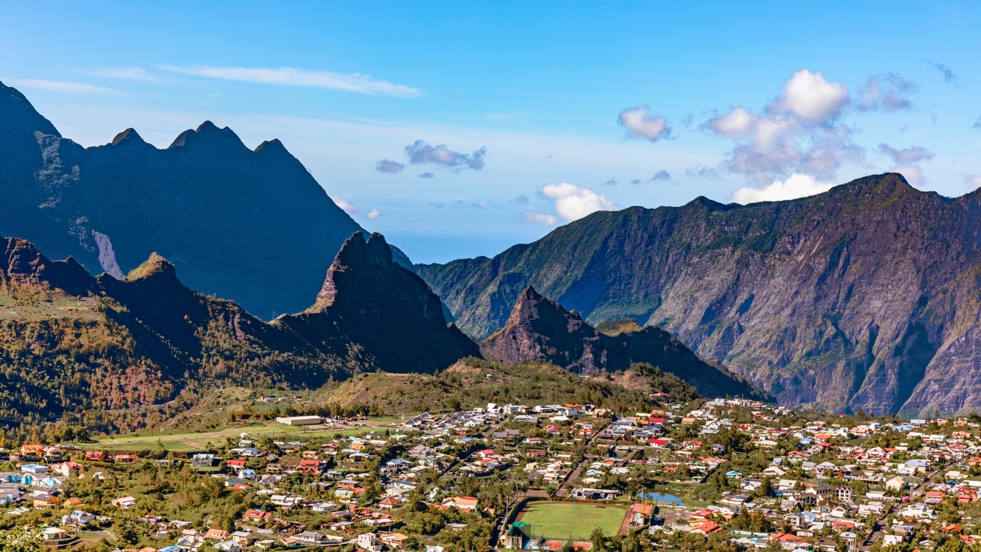
Reunion packs into 40 kilometres of width landscapes running from a coral lagoon to summits above 3,000 metres, a volcano you can walk up to, and a Creole population from every continent. A department of France in the Indian Ocean, its mountainous heart, the Pitons, cirques and ramparts, is a World Heritage site.
What is there to discover on Reunion Island?
The Cilaos cirque
You reach it by the road of 400 bends, cut into the gorge of the Bras de Cilaos. At the bottom, the thermal village, its Creole houses and its local produce: lentils, wine and openwork embroidery. Cilaos is the base for climbing the Piton des Neiges, the Indian Ocean's high point at 3,070 metres, usually over two days with a night at the Caverne Dufour hut. The Fleurs Jaunes canyon is a canyoning classic.
The Salazie cirque and Hell-Bourg
The wettest and greenest of the three cirques, hung with waterfalls including the Voile de la Mariee, visible from the road. Hell-Bourg, a former spa town, is ranked among France's loveliest villages for its verandah Creole houses and their gardens. From here start the trail to the Piton d'Anchaing and the Col des Boeufs, the main walking gateway into the Mafate cirque.
The Mafate cirque, with no road
Mafate is reached only on foot or by helicopter: no road enters it. Around a hundred people live in hamlets linked by trails, and hut supplies come in by helicopter. You enter by the Col des Boeufs or from the Maido, you sleep in family-run guesthouses, and it takes two to four days to cross. It is the island's most singular hiking experience.
The Piton de la Fournaise and the Plaines
The volcano road crosses the Plaine des Cafres then the reddish desert of the Plaine des Sables before reaching the Pas de Bellecombe, the start of the hike to the Dolomieu crater, about 5 hours round trip. You must set off at dawn, as the clouds rise from midday, and check the alert level: access is closed during eruptions and days of intense seismic activity.
The west coast, the lagoon and the highlands
From Saint-Paul to Saint-Leu, the leeward coast holds the beaches and the island's only lagoon, protected by a coral reef at the Ermitage and the Saline. It is also the driest and most touristy area. Above it, the western highlands climb to the Maido viewpoint at 2,200 metres, with the tamarin forest, the Saint-Leu paragliding site and the Jardin d'Eden.
The wild south and the Grand Brule
Between Saint-Pierre and Sainte-Rose, the south coast has no lagoon and no reef: the sea pounds lava cliffs and black-sand beaches. On the Grand Brule, recent flows from the Piton de la Fournaise have covered the road several times, most recently in 2007; you walk on the frozen lava, visit a lava tube with a guide, and the Piton Sainte-Rose church, spared in 1977, stands in the middle of the black field.
Saint-Denis, the east and the Trou de Fer waterfall
Saint-Denis, the main town, lines up the fretwork Creole houses of the Rue de Paris and the Grand Marche. The windward east coast is the wettest and most authentic: cane and vanilla plantations around Saint-Andre and Sainte-Suzanne, Tamil temples, and the Belouve forest from where the trail leads to the Trou de Fer viewpoint, a chasm of waterfalls most often seen from a helicopter.
Cities to visit in Réunion
Featured destinations appear first.
Coming soon.
Réunion in pictures
Reunion Island highlights
Twelve sites covering the volcano, the cirques, the lagoon and the lava coast.
Piton de la Fournaise
A 2,632-metre shield volcano, erupting on average every eight to nine months; a hike to the crater from the Pas de Bellecombe when access is open.
Mafate cirque
A collapse cirque with no road at all, home to about a hundred people in hamlets linked by trails; reached on foot or by helicopter.
Piton des Neiges
The Indian Ocean's high point at 3,070 metres, the extinct volcano that built the island; a night climb from Cilaos for the sunrise.
Hell-Bourg
A former spa town in the Salazie cirque, ranked among France's loveliest villages for its verandah Creole houses and their gardens.
Cilaos
A village at the bottom of its cirque, at the end of the road of 400 bends, known for its baths, lentils, wine and openwork embroidery.
Maido viewpoint
A viewpoint at 2,200 metres over the Mafate cirque, to reach before sunrise, before the clouds fill the cirque.
Ermitage lagoon
The island's only real protected swimming area, behind the coral reef; snorkelling, reef fish and a coconut grove.
Trou de Fer
A 300-metre chasm into which several waterfalls plunge, in the Belouve forest; a viewpoint reachable on foot, or a helicopter flyover.
Grand Brule and the lava road
The area where the Piton de la Fournaise flows reach the sea and have covered the road several times; you walk on the cooled lava.
Voile de la Mariee waterfall
A multi-strand fall tumbling down a green cliff in the Salazie cirque, seen straight from the Hell-Bourg road.
Cap Mechant
Jagged black lava cliffs pounded by the waves on the wild south, fringed by a screwpine forest and coastal paths.
Kelonia
A sea turtle observatory in Saint-Leu, a care centre with display pools, set on a former turtle farm.
Can you climb the Piton de la Fournaise and see the lava?
You can hike to the rim of the Dolomieu crater, about 5 hours round trip from the Pas de Bellecombe, when the enclosure is open. Seeing molten lava means an eruption is under way: in that case the trail is closed, but outdoor viewpoints are set up.
How do you get into the Mafate cirque?
On foot only, via the Col des Boeufs, the Maido, Sans Souci or the Riviere des Galets, on demanding trails; or by helicopter for a drop-off. There is no road and no car in the cirque, and nights are spent in family-run guesthouses, to be booked ahead.
How many days to visit Reunion Island?
A week covers one cirque, the volcano and the west coast. Ten days to two weeks are needed for the three cirques, the wild south, the east and some hiking days, without a long mountain drive every day.
Can you swim on Reunion despite the sharks?
Yes, in the west-coast lagoon, at the Ermitage, the Saline or Saint-Pierre, protected by the coral reef and supervised. Outside the lagoon, swimming and surfing are usually banned by order since the shark crisis, and that ban must be respected.
What is the best time to visit Reunion Island?
The southern winter, from May to November: drier weather, clear skies over the summits, walkable trails. September and October are ideal, with the whales still there and the landscape still green. Avoid February and March, the heart of the cyclone season.
Reunion or Mauritius: which to choose?
Reunion for the mountains, the hiking, the volcano and the spectacular scenery, with few beaches. Mauritius, next door, for the beaches, the lagoon and the seaside hotels. Many combine both, linked by a 45-minute flight.
Do you need a 4x4 to visit Reunion?
No. All the tourist roads, including those of the cirques and the volcano, are paved and done in a normal car. A 4x4 is only useful for a few tracks, such as the Col des Boeufs one, often closed, where you can also park and finish on foot.
When and where can you see whales on Reunion?
From June to October, off the west coast between Saint-Gilles and Saint-Leu, peaking in August and September. They are watched from a licensed boat, sometimes from the coastal path or Cap La Houssaye, and their song can be heard while snorkelling.
Plan your trip to Réunion
Day-by-day itinerary, budget, bookings and packing in a single app.